New at Southampton Boat Show, Stand G088
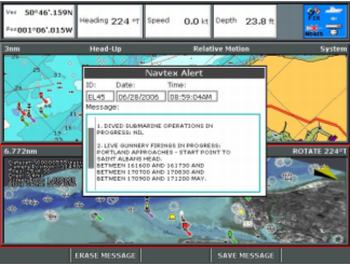
Raymarine’s multifunction displays now support AIS (Automatic Identification System) and NAVTEX data. With this added capability, Raymarine’s multifunction displays offer a comprehensive library of navigational features to make boating a safe and enjoyable experience.
The multifunction C Series displays combine chartplotter, fishfinder, radar, and instrument data. Completely customisable, the C Series can be a powerful single station display or a complete navigation system on a single screen that is both easy-to-see and easy-to-use. Available in three sizes, C70, C80 and C120, the intuitive C Series interface puts the user in command. C Series provides the perfect one-screen information hub for vessels with limited space considerations.
Super-fast, super-bright E Series combines all the features of the C Series with the added benefits of on-board video display, engine monitoring. Simple to install using Raymarine’s no hassle “plug and play†network and available in two sizes, the E80 and E120, can be used in single, dual or multi-station configurations. There are four video inputs, for viewing remote cameras or on-board entertainment, with outputs enabling video images to be shown on remote monitors or flat screens. With one or more E Series display units on board, AIS and NAVTEX sources can be connected to different displays and the data can be bridged/shared across the SeaTalkhs data network. Existing units can be upgraded to received AIS and NAVTEX by installing a new software enhancement.

Raymarine’s C and E Series displays have full 256 colour high-resolution TFT screens to provide the best imaging and resolution for all function displays and are viewable in high bright direct sunlight.
The E Series sophisticated technology maximises the features available from the new and exciting multi dimensional Platinum cartography from Navionics. Platinum cartography provides a massive amount of chart details, including 3-D bathymetrics, and satellite and photographic images of ports and marinas from all around the world. Users can change the satellite images to adjust the overlay transparency to fade out layers, making it easier to see the key information required. Another useful feature is the ability to use helicopter vision, enabling users to look at a port or coastline feature from the sea, or from an elevation.
In addition, the Platinum charts contain useful port services information, showing details such as the location and contact numbers for restaurants, marinas, hospitals, fuel stations and much more. These highly advanced and ‘paper like’ chart details are viewed to maximum potential on Raymarine’s super-fast, super-bright E Series.
Waterproof to CFR46 standards, both C and E Series displays are compatible with SeaTalk, SeaTalk 2, NMEA0183 and NMEA 2000 to provide users with a flexible, easy to use, powerful navigation display.